Call on residents to comment on draft local spatial plan for Big Bay and surrounding areas
09 October 2025
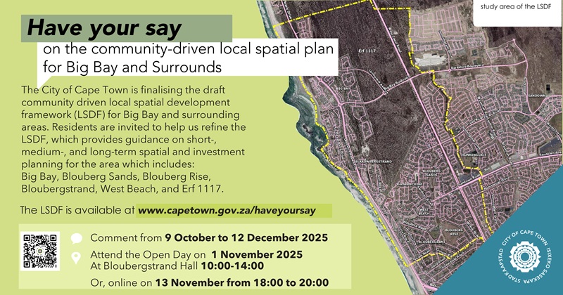
The City of Cape Town invites the public to collaborate with us in refining the community-driven draft Local Spatial Development Framework (LSDF) for the Big Bay area, inclusive of West Beach and Erf 1117, which is owned by the National Department of Public Works. Residents and stakeholders are encouraged to participate in this very important process by submitting comments and proposals; and attending an Open Day on 1 November 2025. The closing date for comments is 12 December 2025.
An LSDF determines the development vision for an area on a local level. Once approved by Council, the City uses the LSDF for guidance when making decisions about development applications and land use in the area and public-led projects and investment.
The Big Bay area is located between the R27 route to the east and the Table View coastline to the west, bordered to the north by the Blaauwberg Nature Reserve, and to the south by Marine Circle and Blaauwberg Road. It is well served by access routes and the MyCiTi bus service, and blessed with exceptional natural environmental assets, such as the scenic West Coast, a coastline attracting kite surfers around the world, iconic views of Table Mountain, and unique biodiversity with threatened Cape Flats Dune Strandveld and Cape Flats Sand Fynbos. The Blaauwbergstrand Village that originated as a fishing village in the 1800s, forms the historic heart of the area with heritage buildings, such as Ons Huisie and Highclere Cottage.
‘The draft LSDF for Big Bay and surrounding areas was an initiative driven by the local community. We appreciate the time and commitment of those residents and stakeholders who worked on the first draft. I want to inform interested parties that the City considered stakeholder comments and that there are substantial changes to the initial draft that was submitted for our vetting. The draft LSDF that is now available for public comment complies with our policies and long-term spatial planning.
‘On this note, I want to encourage all residents to participate in this process. Those who live and work in these areas, and own properties have invaluable knowledge about the unique qualities of their neighbourhoods. We want to tap into your knowledge to refine the framework so that we can have a more complete understanding of how the Big Bay area can be spatially reimagined and revitalised to reach its full potential in coming decades, while also protecting our precious environmental assets. Please collaborate with us, and submit your comments as we are mapping the way forward,’ said the City’s Deputy Mayor and Mayoral Committee Member for Spatial Planning and Environment, Alderman Eddie Andrews.
For more information, and to submit comments and proposals:
Visit the Big Bay Library
Visit the Subcouncil 1 office
The closing date for comments is 12 December 2025
The City is hosting an Open Day and online session as follows:
Process to date
In 2022 Subcouncil 1 supported the community-driven planning initiative to develop a draft LSDF for Big Bay and surrounding areas. This process enabled the local community to initiate and fund the spatial planning project and to also present the community’s views to decision makers.
The Blaauwberg Spatial Association initiated and steered the process to develop a draft LSDF for Big Bay and surrounding areas
The association appointed and paid for professional consultants to draft the LSDF
The draft was submitted to the City’s Urban Planning and Design Department in December 2024 for vetting and compliance with City policies
In partnership with community representatives, the document has been substantially revised for the public participation process that is now under way to allow residents and stakeholders to submit further comments and proposals
All of the comments received during the statutory process will be assessed and considered as the draft LSDF for the area is refined
The contextual background contained in the draft LSDF provides a broad overview of the challenges, needs, constraints and opportunities. It also contains data about the current population and densities, land use patterns, income levels and distribution, employment, and property market.
Some considerations contained in the draft LSDF:
Opportunities
Excellent public transport links to the Cape Town CBD
Potential development corridor along the R27
The Blaauwberg Nature Reserve
Attractive destination for local and international visitors
Challenges
Lack of schools, public health facilities
Limited local employment opportunities within walking distance
Heavy reliance on road-based transport, leading to congestion and pollution
Low dwelling units and population densities
Uncertainty about the future of government owned Erf 1117 and the threat of land invasions
Vulnerability of services infrastructure, in particular for electricity and sanitation
• Threat of climate change and sea level rise, and need for coastal protection
The draft LSDF makes some proposals about the need for coastal protection, extension of the Blaauwberg Nature Reserve to the south, and the creation of continuous biodiversity conservation corridors.
As for urban development, the LSDF proposes:
10 sub-precincts for the area: Northern Corridor; Big Bay Beachfront; Big Bay Dunes; Bloubergstrand Village; Blaauwberg Dunes; Blaauwberg Beachfront; West Beach; Sunningdale Open Space Corridor; Erf 1117; and a proposed Blouberg Nature Reserve Gateway where proposals in terms of spatial planning, development, density, transport and so forth are aligned with each precinct’s unique qualities and location
The creation of three ‘heart’ nodes at the Blaauwbergstrand Village; West Beach, and the intersection of Big Bay Boulevard and Cormorant Road to contribute to placemaking and identity, where residents and visitors can socialise and interact, and where important social events can be hosted
Maintaining or encouraging development nodes with a mix of land uses and densification; with large nodes along the R27 corridor where the MyCiTi bus service operates; medium nodes along Otto du Plessis Drive; and smaller nodes along connecting routes to stimulate economic activity and small-scale opportunities
Higher densities along public transport routes and areas adjacent to economic opportunities; and low densities in environmental sensitive areas
Higher densities along the coast (apart from Blaauwbergstrand Village) so that more properties can benefit from the views; lower densities within the centre of the project area, and higher densities and mixed land uses towards the R27 where there are higher levels of economic activity
Pursue incremental densification through second or third dwellings where these land uses exist as of right in terms of the City’s zoning scheme
All new developments will have to comply with the Koeberg Nuclear Power Station Urgent Protection Zone which sets mobility conditions in case of an urgent evacuation
Beachfront parking and park-and-ride strategy; a tour bus route; and
Creating a continuous coastal walkway from south of Marine Circle to Big Bay
Erf 1117
Erf 1117 belongs to the National Department of Public Works and has been earmarked for the development of housing opportunities for a wide range of income levels.
The draft LSDF proposes some considerations for this large parcel of land, should development be pursued at some point
It is important to clarify that there is no existing development proposal or application for Erf 1117 at this point in time
Erf 1117 is a ‘Site of Coincidence’ designation, and subject to environmental authorisation and environmental studies to consider conservation areas and management principles in development plans and pursue mitigation measures to protect natural areas
Thus, the biodiversity on this site does not prevent development, but the designation seeks to influence how development can happen in a manner that best balances conservation and urban development goals
The Blaauwberg District Spatial Development Framework includes sites of ‘Coincidence’ for justifiable economic and social development, including Erf 1117. These sites were accepted as a planning category in the Environmental Management Framework and adopted by the Provincial authority in 2023 in terms of the National Environmental Management Act
Any future development of this site will have to comply with the Koeberg Urgent Protective Zone that sets conditions for infrastructure (road) capacity in the event of an emergency evacuation; thus, development in this zone must be phased in accordance with additional road capacity to facilitate emergency evacuations
‘We are eager to receive the community’s input. I also want to remind residents of the reality that Cape Town is the fastest growing city in South Africa and that the City must prepare for this growth in a responsible manner, including prioritising the efficient use of available land within the urban edge. This means our neighbourhoods will change over time with higher densities and mixed land uses in appropriate locations. Thus, our city will be transforming over time as we adapt and plan to accommodate a growing population,’ said Alderman Andrews.
Caption: Residents and stakeholders are encouraged to comment on the draft LSDF for Big Bay and surrounding areas. The City is hosting an Open Day on 1 November and an online session on 13 November where attendees will have the opportunity to ask questions. The closing date for comments is 12 December 2025.
End
Published by:
City of Cape Town, Media Office